POTOMAC RIVER REPORT CARD
RIVER HEALTH INDICATOR
LAND
The Potomac River is home to a diverse array of land use types, ranging from dense forests and suburban communities to urbanized cities and tidal wetlands.
Everything that happens on the land surrounding the Potomac affects its water quality. Forested areas are home to the cleanest streams because trees and other plant life stabilize streambanks and naturally filter water before it flows into waterways. Destroying our forests weakens the land’s natural defenses and increases pollution from nutrient and sediment runoff.
Sustainable land management is key to the future health of the Potomac River and its inhabitants. While a significant portion of the land in the Potomac watershed is protected from development (37 percent), population growth in suburban and rural areas – and the infrastructure to support it – are paving over natural landscapes and streamside forests. Roads, housing, parking lots, and other manmade, impervious surfaces are increasing and as a result, urban polluted runoff is steadily on the rise.
Land use improvements in urban, suburban, and rural areas in combination with long-term, common-sense planning can help communities grow and protect our natural resources at the same time.

Urban Best Management Practices (BMPs)
Previous Grade: C+

The health of the Potomac River and Chesapeake Bay rests on the ability of our counties, cities, and towns to responsibly protect local water quality and embrace river friendly development.
Stripped of most natural land cover, urban and suburban areas contribute a significant and growing amount of polluted runoff to local rivers. Population growth and the infrastructure to support sprawling development patterns threaten to exacerbate the problem as forests are torn down and replaced with parking lots, housing, and roads.
Best management practices (BMPs) help mitigate pollution in urban and rural areas include planting trees, restoring streams, and installing green infrastructure.
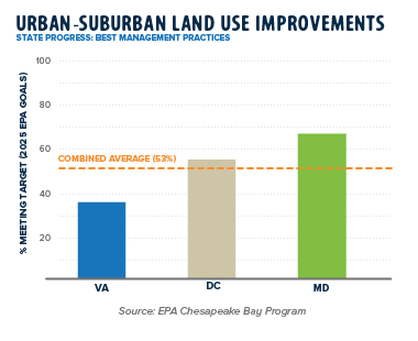
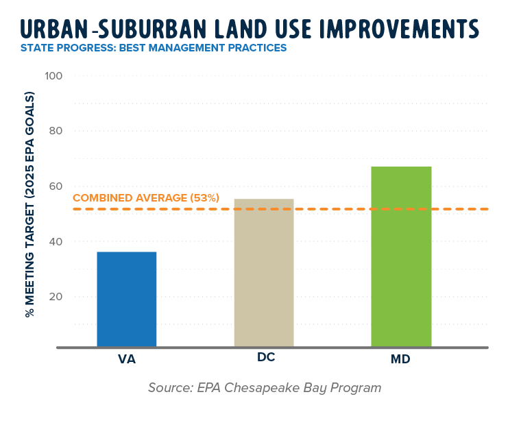
Progress in the implementation of best management practices (BMPs) in urban and suburban areas varies widely across the Potomac basin. Maryland is the furthest along in its progress as the state is meeting 67 percent of its committed goal. Washington, D.C. and Virginia have room for improvement. Together, these three jurisdictions are meeting 53 percent of progress towards the 2025 goals.

Rural Best Management Practices (BMPs)
Previous Grade: B+

Agriculture remains the largest source of nutrient pollution to the Potomac River and Chesapeake Bay. Fortunately, the use of Best Management Practices (BMPs) in rural areas and on farmlands is slowly reducing the amount of nutrient pollutants entering the Potomac, but more work is needed.
Rural BMPs include practices like nutrient management, planting trees and cover crops, and restoring streams. Healthy farms with carbon-capturing soil and regenerative agricultural practices can clean our air and water, and provide farmers with higher quality goods, rather than higher yields based on chemical inputs. Dollar for dollar, BMPs established and maintained in rural areas are typically cheaper and faster to install.
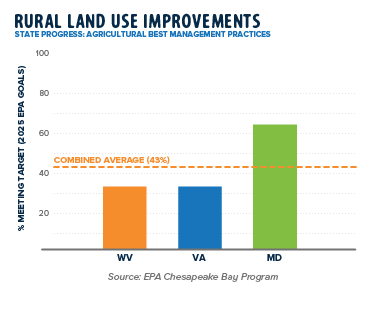
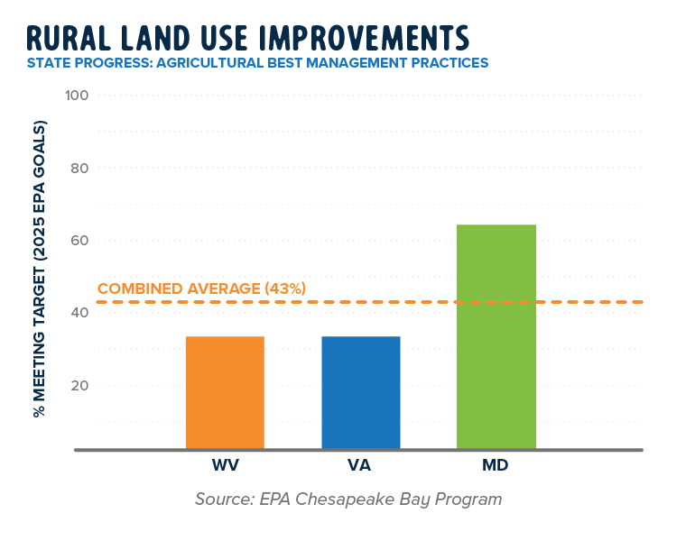
Virginia and West Virginia are both one third of the way towards meeting 2025 goals, while Maryland is approximately doubling that pace. Together, these three states are meeting 43 percent of progress towards the 2025 goals.

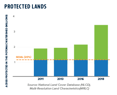
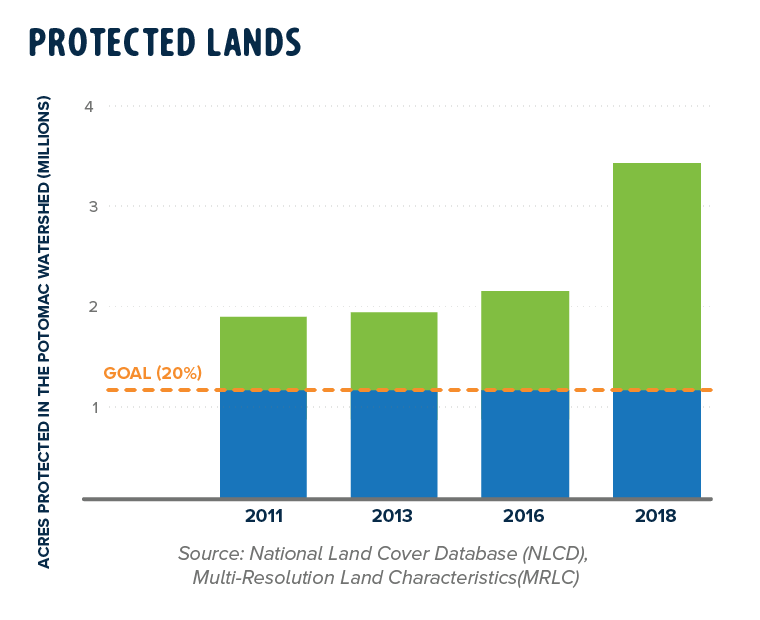
Protected Lands
Previous Grade: A

Protecting land in its natural condition is a long-term investment in the health of the Potomac; land can be protected through conservation easements on private lands, development rights transfers, or the creation of public parks or wildlife refuges.
Overall, land protection efforts in the Potomac region, from federal to local programs, are to be celebrated. Over 3.5 million acres, or 37 percent of total land area, are considered protected from development according to the Chesapeake Bay Program Partnership's Protected Lands Database. The EPA established a bay-wide land conservation goal of 20 percent which the Potomac basin is far exceeding.

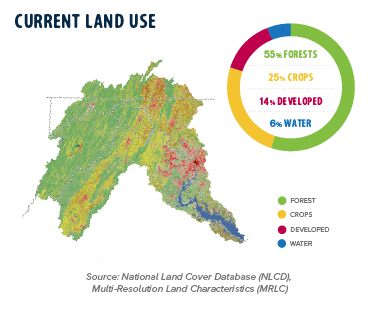
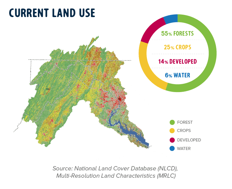
Current Land Use
Previous Grade: n/a

Most land in the Potomac River region is forested (55 percent), but we know these forested areas, if not protected, are at risk from sprawling development and climate threats.
The Potomac region is seeing a slight decrease in agricultural land as farms are sold and development spreads into rural areas. Pollution from urban runoff is increasing and is directly correlated to newly developed acres. Maintaining our forested areas while protecting healthy farmland and targeting development towards thriving urban centers is a smart approach that protects water quality and increases climate resiliency. The current land use grade is tied to the percentage of land that is forested in the Potomac Watershed.
Resources and Methodology
The Potomac is home to a diverse array of land use types, ranging from dense forests and suburban communities to urbanized cities and tidal wetlands. A variety of data sources assess the overall health of these areas. As part of the regional Chesapeake Bay cleanup plan, jurisdictions and the EPA working with the states established pollution reduction goals to restore local rivers and the Bay back to full health. Each state in the Bay region created Watershed Implementation Plans (WIPs) and set target goals to achieve significant pollution reductions by 2025. Each WIP outlines projects and programs the jurisdiction will undertake to meet pollution reductions.
It is important to note that not all lands under conservation are protected equally. In many cases, conservation easements or transfer of development rights prevent urban or suburban development, but don’t require landowners to implement water quality practices. The NLCD database is also dependent on the accuracy of local reporting and it is possible some jurisdictions were not counted in previous years due to data availability, tracking and reporting.
The Urban-Suburban and Rural Land Use Improvements (also known as Best Management Practices, BMPs), are directly related to state WIPs. It’s important to note that the numbers for these BMPs represent entire statewide geographies and data include areas outside of the Potomac watershed. Not all BMPs are created equal; urban and rural BMPs vary by amount and type of pollutants reduced.
Data for the Land indicator are provided by the EPA Chesapeake Bay Program.
 Land
Land Pollution
 Habitat
 Fish
Fish People
 Back to the River


 Printed
 Press
Press